National Institutes of Health, Bethesda, Maryland
Analysis and Interpretation of Aerial ImageryAnalysis and interpretation of aerial photographs of the project area produced an abundance of information that, in conjunction with documentary research and excavation, greatly enhanced the ability of the investigators to identify areas of potential archeological and historical importance, and to delineate areas likely to have been disturbed by construction in years gone by in ways that impaired the integrity of these areas. Aerial photography, as with all sorts of remote sensing techniques, can not be employed in lieu of excavation, since excavation is required in order to "ground truth" landscape features that are suggested by remote sensing data. Such features can only be identified with certainty by first hand examination of physical attributes.
Aerial photographs were obtained and analyzed by Environmental Research, Inc. (ERI). Black and white photographs taken so that each succeeding frame overlapped the previous by 60% provided stereoscopic coverage of the project area. Such "stereo pairs" for the project area were obtained for a number of years so that the various episodes of site development could be detected. The earliest of these years was 1937. Photographs taken in this year show the site just as construction was beginning on Building #1 of the NIH Bethesda Campus. Other aerial stereo pairs obtained and analyzed were taken in 1944, 1951, 1957, and 1964. All of these aerial photographs reveal a number of landscape features of considerable importance to the interpretation of archaeological findings. The features of greatest importance to the immediate concerns of this report, identifying archeological sites and arriving at preliminary determinations of significance in terms of national register criteria, will be presented and discussed below, according to the areas in which they were observed.
Area A (18MO464)
Click on the thumbnails to see the full image.
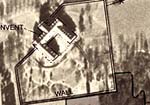
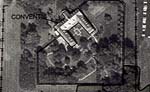
Lawn has filled the area of exposed soil by September 24, 1964, as evidenced by an aerial photograph taken then. Some small trees or shrubs have sprung up in the formerly bare strip. Other than these landscape changes, the scene appears little different than in the 1957 photo.
1964 Aerial Photo
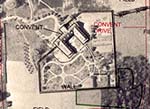
Among the useful pieces of information these photos provide is that ground surface to a depth unknown but possibly less than a foot has probably been disturbed by tree removal west from Convent Road over to approximately 60 feet from the western convent wall. Also, more surface disturbance has occurred in the area that appears as denuded in the 1957 photograph, bounded by the approximate present locations of STP's D3 to B3 on the west and STP's E16 to C16 on the east. Of course, ground disturbance is likely, too, for 10 to 20 feet north of South Drive. The results of archeological fieldwork must be interpreted with this in mind.Consolidated Areas B and C (18MO462, 18MO463, 18MO465)
The vicinity made up by the consolidation of Areas B and C and the intervening land is larger than that of Area A and contains many more features of interest in the 1937, 1944, 1951, 1957, and 1964 aerial photos.
In the 1937 aerial photo, structures seen in the consolidated area are residential and perhaps agricultural. Center Drive has yet to be built, although the construction of Building #1 has begun in what will soon be the area on the other side of Center Drive. The course of the unnamed, intermittent stream, flowing from west to east, is clear along the top of the frame. "Treetops," the Woodward estate, can be seen in the upper right hand quarter of the frame, as can be its ancillary structures (cottages and dependencies) to the southwest of the main house. A garden or recreation court, seen as a rectangle with its long axis running north-south, is southeast of "Treetops". Of particular interest is the small road that runs from West Cedar Lane at the top of the frame, departing from West Cedar Lane just right of center, which terminates in a circle drive approximately half-way down the frame. The upper half of this road will become West Drive, although the lower half of West Drive will depart to the west from the course of this road, forming a 90 degree juncture with the eventual alignment of Center Drive. At about the midway point of this road--in fact, where the course of West Drive will begin its westward deviation-begins a line of several structures immediately on the west side of the road. In addition to the various structures located west of this road, an area of light toned and medium toned material is visible just east of the road. This earthen type material appears to have been brought in from some other location possibly from excavation of foundations for Building 1, under construction at this time.
Artifacts dating to the late eighteenth or early nineteenth century were found on a wooded knoll (18MO462 - The Knoll Site) between present day West Drive and the large parking lot to the west of West Drive. (The entrance to this parking lot is at the junction of West Drive and Center Drive.) The artifacts (discussed in a later section of this report) are of the sort that might have been in use at a late eighteenth or early nineteenth century farmstead. Thus the complex, or complexes, of structures on both sides of the road might have been a part of such a farmstead. Fields may have been located in what appears in the 1937 aerial photograph as wooded area, and in and around the area occupied by "Treetops".
By January 24, 1944, the road leading south from West Cedar Lane had been widened. Perhaps it was also paved, in part to provide more comfortable access to the large physicians' residences that appear in the 1944 photograph. By now, the structures on the west side of the road have been removed, only a remnant of one of the structures is visible. The road actually appears to widen a bit more to the south of the entrance roads to the physicians' residences, then narrows near the cluster of structures ancillary to "Treetops" (on the east side of the road). Here, it now continues south, past the circle drive, which is to the east of the extended road, and terminates at a fence line that runs straight along the south side of Building #9, which has been constructed in the years intervening since 1937. Between the terminus of the road and Building # 9 are numerous smaller structures, also constructed in the intervening years and made accessible by the extended road. A number of other major NIH buildings appear in the general vicinity of the project area as it is seen in the 1944 photograph that did not appear in the 1937 photo, including the completed Building #1, as well as Buildings #s 2, 3, 4, 5, and, of course, 9.
In the September 28, 1951 aerial photograph, Center Drive appears, as does the current alignment of West Drive, which now displays a uniform width, and terminates at Center Drive in an approximate "T" intersection. The extension of the road (that had predated West Drive) is no longer in evidence; Building # 10 is under construction and the building site has obliterated any trace of the extension. All trees have been removed on both sides of West Drive near its intersection with Center Drive. In place of the trees, lawns extend about 60 feet to the west of West Drive and over 100 feet to the east. A long, north-south scar in the lawn on the east of West Drive suggests recent installation of utility lines to Building # 10. Trees are still in leaf in the 1951 photo and so obscure much of the area of "Treetops". Clearly visible just to the east of the physicians' residences, an area not under canopy, is a baseball diamond. Trees on the crest of the knoll to the west of West Drive appear fuller than those down slope. These are the same trees that appear with no leaves in aerial photos taken in the winter months, while the trees down slope appear foliated. Therefore, the trees on the crest of the knoll are probably deciduous, and those ringing the crest, down slope, are likely coniferous.
Many more parking lots are visible in the April 15, 1957 aerial photo than appear in earlier aerial photos. Large lots are to either side of the enormous Building # 10, and smaller lots are in front of the building. Building # 20 has been constructed and can be seen northwest of the intersection of Center Drive and West Drive. The parking lot that borders on the southwest the consolidated Area B and C, which arcs from the south to the west quadrants of the compass, just northeast of Building # 20, and another lot have been constructed just north of Building # 20. Deciduous trees are not yet in leaf, so a few small coniferous trees or shrubs that occupy the area to the east of West Drive, now otherwise in lawn for about two hundred feet, show up clearly. A denser growth of coniferous trees was in this area in December of 1996. The lawn area ends at a north-south fence. On the other side of the fence are structures that are ancillary to "Treetops". The deciduous trees that are atop the large knoll west of West Drive remain.
A new sidewalk has been constructed along the west side of West Drive which appears in the September 24, 1964 aerial photograph. Numerous cars are parked along the east side of the road. Parking space seems to be short, overall, because every available space in the frame is occupied by a vehicle. The arcing parking lot to the northeast of Building # 20 has been extended to more than twice its length in the 1957 photo, and now crosses through the course of the unnamed intermittent stream. Trees are in full leaf, and little can be made out in the vicinity of "Treetops" and its ancillary structures. Buildings 31, 31A, and 31B have been constructed not far from "Treetops" to the east. They are so close by that they must have been visible from the main house, and noise would likely intrude upon the environment there.
The site developments documented by the aerial photos, as described above, would very likely have disturbed a good bit of the archeological record, that is, the archeological materials within a soil matrix, as it was originally deposited. The pattern of disturbance at Area A (18MO464) was complex. Some locations might not have been greatly disturbed, yet in others the uppermost inches and feet were probably churned by landscaping and construction of various sorts.
At the consolidated Areas B and C, the knoll to the west of West Drive covered by deciduous trees (18MO462) seems not to have been disturbed by the activities indicated in the series of aerial photos that began in 1937. This comprises part of the current project area, and one where some of the most interesting artifacts were recovered.
On the east side of West Drive, to a distance of two hundred feet or more, or the distance to the extant north-south fence, the area has undergone considerable disturbance (18MO465). The alignment of the road that predated West Drive came through this area. Construction drawings indicate that a storm drain was installed along the approximate location of the STP "17" line of the grid established for the archeological investigation, and a gas line along the "18" line. The trench for one of these might be the one indicated by the scar in the 1951 photo.
Developments to the east of the present day north-south fence mentioned just above were more difficult to ascertain because the area was sometimes covered by tree canopy in the historic aerial photographs. Here, as elsewhere, disturbance was not present everywhere, and varied in degree. The possible garden that appears to the south of the farm cottage can be seen only in the 1957 photo, for example. Of particular interest is the area where material appears to have been deposited in the area south of building 15A in 1937. When combined with the results of excavations performed as a part of this Phase I archeological investigation, nonetheless, the aerial photos can be used to eliminate some areas from consideration as being potentially eligible for inclusion on the National Register of Historic Places, and can suggest the importance of other areas. Specific features observed in aerial photos will influence the interpretation of fieldwork findings, as will be discussed below.
Click here for more information on National Institutes of Health projects
Back to Projects listing